Kaula - A Crescent-shaped Island
Approximately 23 miles (37 km) southwest of the island of Ni'ihau lies the little Kaula Island, which has the form of a crescent. Even though the little island was known to the Native Hawaiians who visited it, it is thought that no one ever resided there permanently. Two stone buildings, which may have been heiaus, have been discovered close to the island's top (ancient temple sites). The island has a total surface area of 158.2 acres (0.64 km2), with the highest point which is 548 feet (167 m) above sea level.
Author:Jane RestureSep 30, 20228.8K Shares261K Views
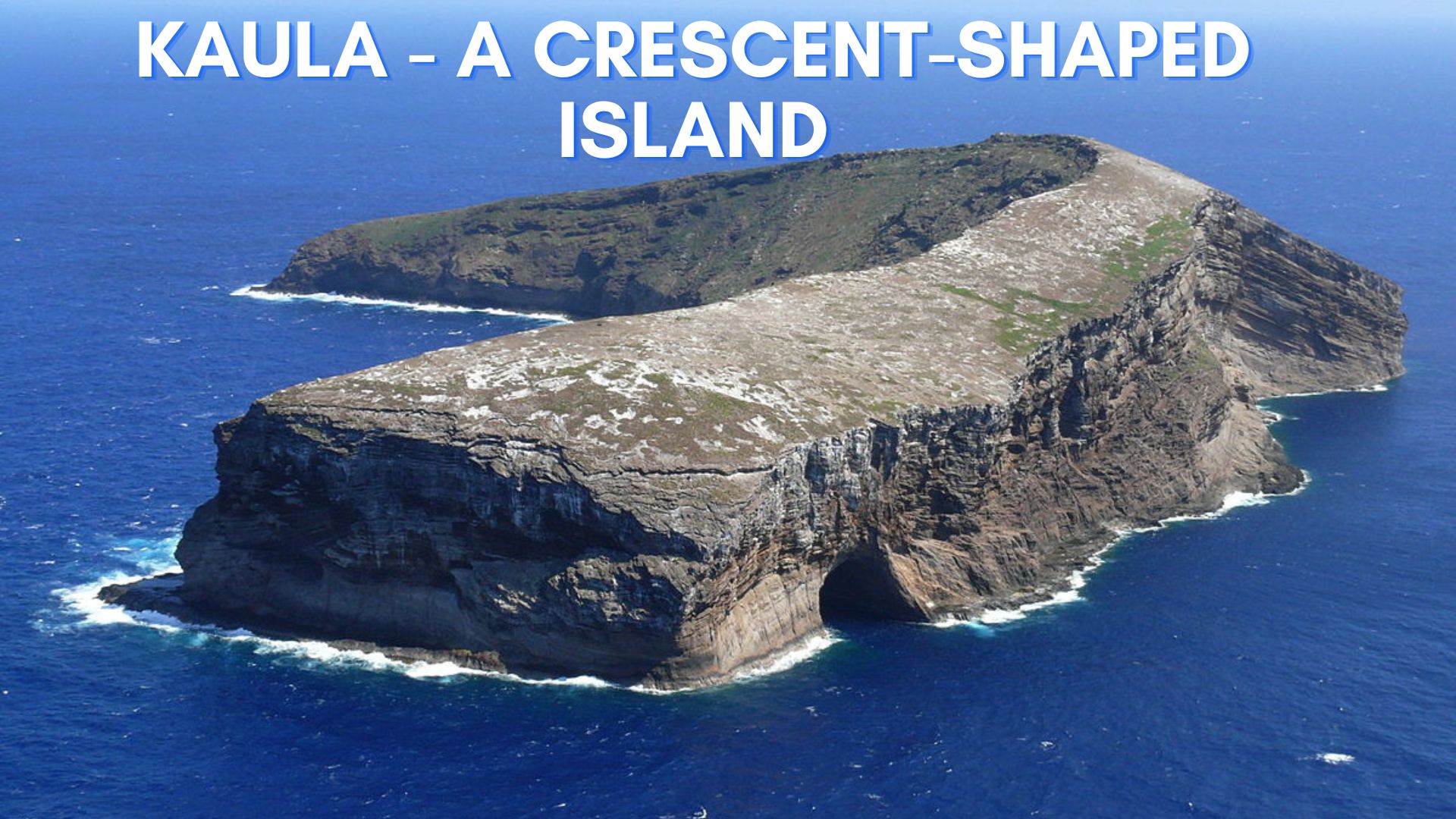
Approximately 23 miles (37 km) southwest of the island of Ni'ihau lies the little KaulaIsland, which has the form of a crescent. Even though the little island was known to the Native Hawaiians who visited it, it is thought that no one ever resided there permanently.
Two stone buildings, which may have been heiaus, have been discovered close to the island's top (ancient temple sites). The island has a total surface area of 158.2 acres (0.64 km2), with the highest point which is 548 feet (167 m) above sea level.
The Geography Of Kaula Island
It is situated around 150 mi (173 mi; 278 km) west of Honolulu and 23 mi west-southwest of Kawaihoa Point on Niihau. The island is made up of a volcanic tuff cone that sits atop a bigger shield volcano that is underwater.
The island rises to a height of 548 feet at its highest point. On the flanks of the island, the water has carved out substantial sea cliffs. On the island's northwest side lies a sizable cave known as Kahalauaola.
Kaula is defined by the US Census Bureau as Census Tract 411 in Kauai County, Hawaii. The deserted island contained 158.2 acres of land according to the 2000 census (0.640 km2; 0.2472 sq mi). The island is steadily eroding as a result.
What's Going On With Kaula Island?
Due to erosion, the island is gradually becoming smaller. On Ka'ula's northwest side, there is a sizable cave called Kahalauaola (Shark Cave). In 1932, the previous United States Lighthouse Service constructed a lighthouse atop Ka'ula, which was used until 1947.
Since 1952, the island has been a target for bombardment by the U.S. Navy, and it's possible that unexploded ordnance still exists there. For this reason, getting permission to land on Ka'ula from the US Navy is required. Fishing and scuba diving are popular activities in the seas close to Ka'ula.
Kaula's Ownership Debate
Since 1952, the US Navy has used Kaula Islet as a place to practice bombing. If you want to land there, you must get permission from the Navy first. In 1978, the state of Hawaii claimed Kaula as its own and turned it into a seabird sanctuary.
Even though the island's ownership is still up for debate, the Navy continues to use its southeast region as a target for aircraft bombing and strafing with inert material.
Traveling By Boat
Niihau Island is privately owned and inaccessible to the public. The closest public port is at Port Allen, Kauai, which is 55 miles away from Kaula Rock. Even so, landing at Kaula Rock is only attempted in very calm waves. Even so, success cannot be guaranteed.
Using A Helicopter To Get There
A helicopter landing atop Kaula Rock needs approval from the U.S. Navy and perhaps the State of Hawaii.
People Also Ask
Can You Go To Kaula Island?
There are just two options: by helicopter and by boat.
Which Countries Have Kaula's Ownership Debate?
The Kaula Islet was first utilized by the US Navy in 1952 as a target practice area before being seized by the state of Hawaii in 1978 and transformed into a seabird sanctuary.
Why Is Kaula Island Shrinking?
The island is progressively shrinking as a result of erosion.
Conclusion
This is one of the best places to visit in summer! Many sooty terns, brown noddies, boobies, and wedge-tailed shearwaters live there. No beaches are available for landing at Kaula Rock, and the island is surrounded by sheer cliffs on all sides. In the island's northwest corner lies a sizable sea cave.

Jane Resture
Author
Since she embarked on her first world trip in 2002, Jane Resture spent the past decades sharing her personal journey and travel tips with people around the world. She has traveled to over 80 countries and territories, where she experienced other cultures, wildlife she had only read about in books, new foods, new people, and new amazing experiences.
Jane believes that travel is for everyone and it helps us learn about ourselves and the world around us. Her goal is to help more people from more backgrounds experience the joy of exploration because she trusts that travel opens the door to the greatest, most unforgettable experiences life can offer and this builds a kinder, more inclusive, more open-minded world.
Latest Articles
Popular Articles